Tocht Mountainbike La Faurie - pusteaux - agnielles - col longeoire -  - Photo

pusteaux - agnielles - col longeoire -

 jcpistono
jcpistono

Gebruiker

© OpenStreetMap contributors
Lengte
Lengte
43 km
Max. hoogte
Max. hoogte
1621 m
Positief hoogteverschil
1278 m
Km-Effort
Km-Effort  
60 km
Min. hoogte
Min. hoogte
799 m
Negatief hoogteverschil
1275 m
Boucle
Boucle
Ja
Datum van aanmaak :
2021-08-17 11:46:52.911
Laatste wijziging :
2021-08-17 16:18:58.981

(0 Bericht)

Mountainbike
Mountainbike
3h42
Moeilijkheid : Gemakkelijk

Scan deze QR-code om de tocht te openen in de SityTrail-applicatie

Gratisgps-wandelapplicatie

Logo SityTrail SityTrail

IGN / Geografische instituten

SityTrail uit de App Store downloaden SityTrail uit Google Play downloaden

Logo SityTrail SityTrail World

De wereld gaat voor u open

SityTrail uit de App Store downloaden SityTrail uit Google Play downloaden SityTrail op Huawei AppGallery downloaden

Over ons

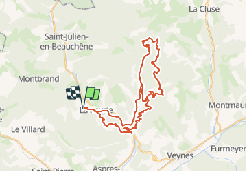
Tocht Mountainbike van 43 km beschikbaar op Provence-Alpes-Côte d'Azur, Hautes-Alpes, La Faurie. Deze tocht wordt voorgesteld door jcpistono.

Beschrijving

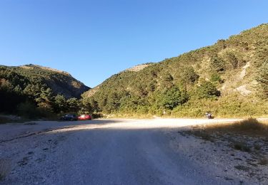
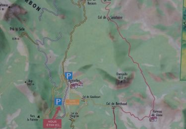
pusteaux - seilles - pont la dame - cil angelus - agnielles - recours - la lauze  - col angelus - agnielles - pusteaux
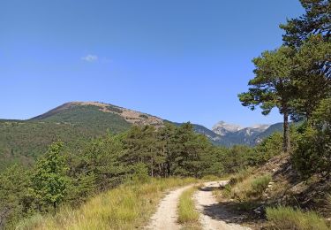
43km 1275mdev - quasiment en totalité  sur pistes forestieres - tres agreable et facile en vttae

Hoogteprofiel

Plaatsbepaling

Land:
France
Regio :
Provence-Alpes-Côte d'Azur
Departement/Provincie :
Hautes-Alpes
Gemeente :
La Faurie
Locatie:
Unknown
Vertrek:(UTM)
716585 ; 4938630 (31T) N.

Wandeltochten in de omgeving

Tocht Stappen La Faurie - R40   Les Marmites du Diable - Photo
Stappen
GUIDE+

Stappen

Medium
(6)
La Faurie, Provence-Alpes-Côte d'Azur, Hautes-Alpes, France
5,9 km | 10,4 km-effort
2h 7min
Ja
Tocht Stappen Aspres-sur-Buëch - R42   La Longeagne - Photo
Stappen
GUIDE+

Stappen

Heel gemakkelijk
(1)
Aspres-sur-Buëch, Provence-Alpes-Côte d'Azur, Hautes-Alpes, France
7,1 km | 11,2 km-effort
2h 23min
Ja
Tocht Te voet Montbrand - 9587037(1) - Photo
Te voet
GUIDE+

Te voet

Gemakkelijk
Montbrand, Provence-Alpes-Côte d'Azur, Hautes-Alpes, France
3,5 km | 4,6 km-effort
1h 2min
Ja
Tocht Te voet Aspres-sur-Buëch - 9587028 - Photo
Te voet
GUIDE+

Te voet

Gemakkelijk
Aspres-sur-Buëch, Provence-Alpes-Côte d'Azur, Hautes-Alpes, France
3,4 km | 5,3 km-effort
1h 12min
Ja
Tocht Mountainbike Aspres-sur-Buëch - Gorges de l'Agnielle - Photo
Mountainbike
jeanboulay

Mountainbike

Medium
Aspres-sur-Buëch, Provence-Alpes-Côte d'Azur, Hautes-Alpes, France
12 km | 16,7 km-effort
2h 25min
Ja
Tocht Mountainbike Saint-Pierre-d'Argençon - HA J3 long - Photo
Mountainbike
thierryd

Mountainbike

Heel gemakkelijk
(4)
Saint-Pierre-d'Argençon, Provence-Alpes-Côte d'Azur, Hautes-Alpes, France
34 km | 42 km-effort
2h 45min
Neen
Tocht Stappen La Faurie - les marmites du Diable - Photo
Stappen
Thierry.T

Stappen

Moeilijk
La Faurie, Provence-Alpes-Côte d'Azur, Hautes-Alpes, France
6,1 km | 10,4 km-effort
2h 59min
Ja
Tocht Stappen Montbrand - montbrand - Photo
Stappen
xcreator

Stappen

Gemakkelijk
Montbrand, Provence-Alpes-Côte d'Azur, Hautes-Alpes, France
3,8 km | 5,1 km-effort
1h 3min
Ja
Tocht Stappen La Faurie - Agnielles - Marmites du Diable - Photo
Stappen
kurt-vh

Stappen

Zeer moeilijk
La Faurie, Provence-Alpes-Côte d'Azur, Hautes-Alpes, France
15,6 km | 28 km-effort
6h 15min
Ja


Sluiten
Mijn abonnementen